Extracts from conversation ...
-Journey 1 is an installation of 33 photographs of the Pedieos river in Cyprus. Can you tell us about the installation and the history of the Pedieos River?
- Pedieos is the longest river in Cyprus. In the past it had water running all the year round. However over the last century it has water only during the winter months, with water from the rains and the meting snow in the mountains. In recent years it is mostly dry due to lower levels of rain in the island, and due to the construction of new large damns. The river originates in the Troodos mountains and flows initially North down the mountains, then turns Northeast before entering Nicosia (the last divided capital of the world), then takes an eastern direction until it meets the sea just at the north of the occupied town of Famagusta. Two thirds of the Pedieos River is under Turkish occupation. Excavations have found that t
he first inhabitants of Cyprus were attracted by what was then a rich river.
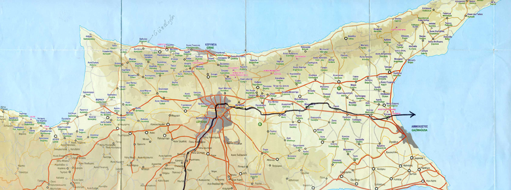
In order to find our way along the river I used two maps, both purchased from a local kiosk, one in Greek (with data that has not changed since 1974) and another entitled “Occupied Area Map” showing the roads as they are now, with the villages’ names shown both in Greek and the subsequent new names given by the Turks (see scanned map). I also used a GPS to measure distances and find my way around the off-road areas. With these at hand and my Rollei 6800AF (medium format) I set out for my photo-journey which lasted from the beginning of December ‘05 to mid January ‘06. I decided to take photos at intervals of exactly 2,5km standing on the right bank of the river, taking a picture of the river looking the left bank. By using this ‘arbitrary and spontaneous’ method of taking a photo, I wanted to avoid employing classical traditional methods of photographic compositions, staging, framing, lighting and regardless of time of day. There was no going back for a second shooting or waiting for better weather conditions, I photographed and continued my journey. Each photo is systematically accompanied by information of its location (this data is engraved on the steel-mounting frame holding the photo on the wall), with the fix given by the Global Positioning System (GPS) points of longitude and latitude. These numbers are defined as the intersection of imaginary great circles on the surface of the earth passing through the North and South poles intersecting at right angles parallel lines to the equator.
Garbage, dead cattle and barbed wire were often seen on this journey. In the North of the island, it is polluted by the spills from a badly maintained sewage treatment plant. Seen from a larger perspective, it is a reflection on environmental and political issues in a form of a data bank.
-You are putting all these disparate elements in all the three proposed journeys here that have a common location of departure and then you document the journey’s landscape, in this case the river crossing your divided country. Putting politics aside you mention that one of the reasons that the river is drying out is a result of climate change, global warming. Is this ecological preoccupation making parallels to an ongoing political conflict …
-There is a political conflict that has been going over years and an environmental greenhouse problem that is happening on a much more global level that has been happening for years with no signs of finding solutions. I wanted to somehow try to deal with both these issues.
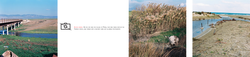
- The insertion in the 82,5km River of ‘Access Denied’ is in fact confirming the victimization and isolation of the landscape via the path you follow here.
- Many avoid saying the word invasion/ occupation so as not to seem ‘extremist’. But the plain truth is by far louder than any effort to avoid to face it or to change the facts. This truth is reflected in this landscape series. Here we are no longer a witness or recorder of what is/was but can only imagine. Access denied, is omnipresent where I come from as well as the military occupation. I have attempted to capture this. Access denied is like a ‘Do Not Touch’ sign where it has a double psychological meaning, actually invites you to want to touch even if the thought hadn’t even crossed your mind…It’s a blank gap between a reality and reflection, strangely enough this space in between can be exactly the point where you’re best able ‘to access’ the piece.
- It shows the absence of caring for the river through eco-politics, and reflects a kind of unstable “territorial anxiety” that a situation like this can induce, particularly when you show the map of Cyprus split and the place-names renamed. It’s a territorial anxiety involving a geographic, political, economic and social burden. I heard you once describe this piece as ‘Green-art’ in relation to ‘Green-Peace’, stating that <green> Peace is an endangered concept.
- Yes ‘Green art’ has a nice ring to it don’t you think? In this piece what I find of interest is that you see a scruffy fringe of Cyprus with everything looking quite banal, at least to anyone familiar with the topology of the island, but then you realize that there are dead cows thrown in the river, there is garbage on either side, the water has more or less dried out and a large part of the little water still flowing is sewage. Nearing the Delta of the river, it is split with barbed wire. What at first appears to be ordinary is quite extraordinary, and perhaps more interestingly the opposite is also true, the adoption of the extraordinary into the ordinary fabric of the place
-You seem to pull back and show the surroundings, the back road as it were, searching for the soul of the place.
- Roads not taken, I wanted to find out what was happening “behind the scenes” and how it differed from what newspapers and travel guides tell you to see.
-Did you choose not to have people in these photographs?
-No, not having people in the photos was not a conscious decision it just happened that there was nobody out there. But having said that, having no people gives the piece a feeling a sense of quiet…and the viewer standing on the outside flicking through, viewing a quieter static whole…it looks so green from a distance and yet in many ways isn’t it ironic that war is about land, its about disputed soil who has the rights to it, whose history is contained in that soil and the reality out there completely changes according to one’s own polarized perspective of it, according to where they come from etc
-How did you choose your format and presentation? You come from an art background, how important is the photographic technique or high production value to you? It is no surprise that you have also made a number of small sketches on paper based on these photos, where you have inserted narrative and text.
-For this piece I like the feeling that “old fashioned” non-digitalized film photography gives, using a medium format film evokes memories of the way people used to take photographs. I wanted that physical relationship, albeit blown up, when we get our holiday snaps, that everyday situation. Photos which were non-stylised, which it didn’t matter if they were out of focus or technically immaculate and I didn’t want them framed or printed in any “high tech” versions abroad but locally in my area printers shop. That was important to me. I also mirror-print each image so as to be viewed on both sides and the reflection image as one turned to the next image. I printed them on photo paper and simply folded the paper and locked them in Perspex sheets with each photo’s data carved on the side like a sequence in a book, trapped, sealed unable to escape. The small sketches were done much later on, with ink on faded black and white photocopies…
- What are your feelings about the reversal or reflection of the images you use here? To me, it operates like a flashback; it reminds you to look back, literally…but if opened the viewer realizes that they are seeing half of something. Either they will flip back and forth and see the other half reflected or they will carry it in their head and continue to piece together the journey.
- Uprooting and removal surrounds me, and this is also mirrored in this piece
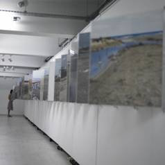
-And the oversize book on the wall is this to work as photographic ‘literature’? Would this narrative differ from viewer to viewer?
-Like a river flowing, the “flow” changes as the viewer flips through this journey. It’s an attempt to create a visual narrative out of topographical documentary. I realized that one possible reading concerned information, hence the ‘book-format’, intimate yet blowing the pictures up makes one feel “small” in proportion to what they are reading, but at the same time are physically immersed into the ‘book’. Its like watching giant photographs. I like that kinetic manual movement and the viewer’s interaction, and at what stage they leave the ‘page’ open for the next viewer…it also is reminiscent of the flow of water.
- Is that why you place great emphasis in information?
- It is like pinning the moment of that particular experience so that the viewer may revisit the exact location and perhaps this makes this experience more real and valid. The problem was how to select this experience that is meaningful out of the whole and trace the whole river throughout.
- And it is about the pressure of being there on the other side, the psychological burden. Did you feel at any moment unsafe? The final photograph points to the social impact of the visible boundaries by conflict.
-Yes, in three instances. Taking photographs at the green line with all the military paraphernalia, and then passing in front of Turkish military compounds, especially once when a Turkish soldier aimed at us with his rifle to intimidate us (at least that what I thought he was doing, I did not stay to find out) . But most of all at the delta of the river, where I had to enter an area encircled by barbed wire, where a sniper could easily have shoot me without a second thought. At that point I felt like a war journalist and I was scarred to death. I don’t know what drove me to risk it and I would never want to go through that again. It’s indeed a wounded site in many ways as it is divided twice.
Instructions to install : '82,5km' which consists of 33 photos in plexyglass on a wall of a length of approximately 20 to 25M long.
|
|
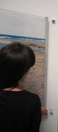
Predetermine the distance between which each photo and height from floor. Then place the special measuring stick at the place where the photo will be installed. With a pen or pencil mark the 4 points (two at the top and two at the bottom) where you will screw the top and bottom brackets that will hold the photo. Then remove the stick and install brackets where the markings are. The distance between each photo should not be less than 40cm. This way the viewer can “enter” between two photos of the installation. |
|
|
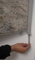
With the help of another person, place the metal edge of the photo on the lower bracket |
|
|
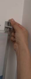
First place the top screw and screw it, but without tightening yet. This task is helped if you shake the photo slightly, ensuring that screwing can be done by hand. |
|
|
Do the same with the lower screw |
|
|
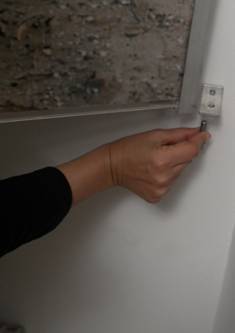
With the help of an alen-key tighten the top screw so as to lift the photo just millimeters from the top bracket, enough for it to swing freely.
Repeat the operation with the bottom screw, only this time ensuring that you don’t tighten too much. Just enough so that the bottom of the photo does not shake around its bottom screw. If you tighten too much you risk dislodging the brackets from the wall, or even worst, destroying the thread inside the metal edge of the photo. |
|
|
This is how the installation should look. To ensure the photos are placed in the right sequence, we include with the present, copy of the book “Do You Believe in Water? Nicosia-Cyprus 2007 ISBN 9963-8644-4-9”, in which you can find the sequence. |